An astronaut aboard the International Space Station took this oblique photograph of the Sulaiman Mountains in central Pakistan.

An astronaut aboard the International Space Station took this oblique photograph of the Sulaiman Mountains in central Pakistan.

On April 29, 2024, Airbus launched the Pléiades Neo Next program to expand its very-high-resolution Earth observation constellation.

Space Flight Laboratory (SFL) confirmed that six radio frequency geolocation microsatellites developed for HawkEye 360 of Herndon, Va., successfully communicated with ground control.
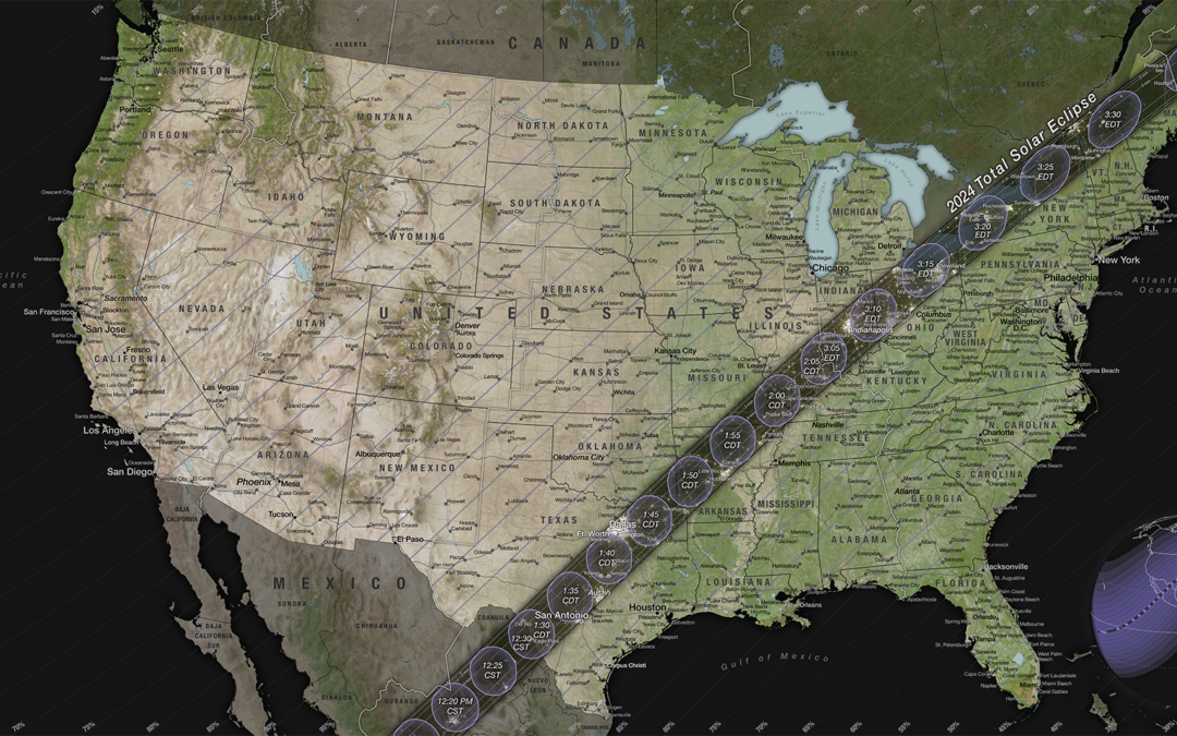
On April 8, 2024, most of North America will have the chance to see the Moon pass in front of the Sun during a solar eclipse.
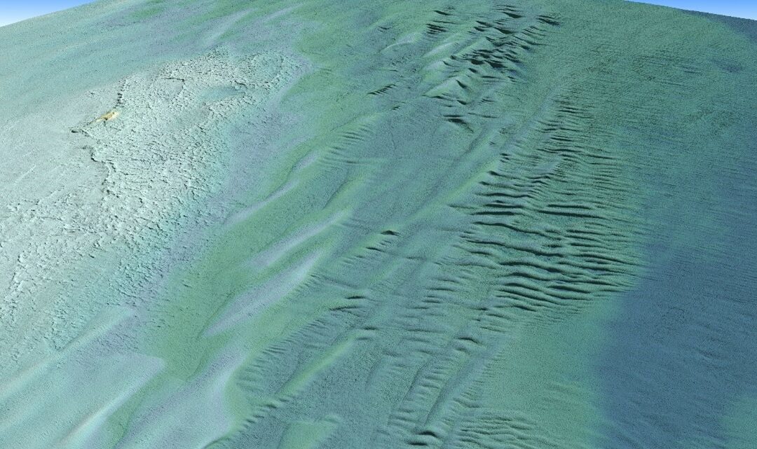
Tetra Tech Inc. used a Teledyne Optech CZMIL SuperNova Topobathymetric lidar system to successfully complete a project for the National Oceanic and Atmospheric Administration (NOAA) to update all its bathymetric maps in the Great Lakes region, which includes refined maps of the marine ecology.
Zurich, Switzerland – May 13, 2024 – SwissDrones, a leading aerial intelligence company, has announced the closing of its Series B equity growth funding round, securing over USD 10 million from a consortium of investors including aviation investor DiamondStream...
KENNEDY SPACE CENTER (FL) – The International Space Station (ISS) National Laboratory is soliciting flight concepts for technology development that would utilize the space-based environment of the orbiting laboratory. This solicitation, “Technology Development...
VANCOUVER, BC — Global technology company TELUS accelerates the reach of its strategic investment arm and announces the launch of TELUS Global Ventures. This rebranding comes in light with the desire to position the company as a global leader seeking new investment...
Geospatial Insight (GSI), a leading provider of global climate and risk intelligence, has announced the integration of Spatial Days, experts in online geospatial data management and GIS/Earth Observation software development to enhance its online climate service...
Germany’s Federal Agency for Cartography and Geodesy (BKG) will continue to manage production of pan-European datasets after signing a new agreement with EuroGeographics. As a result, BKG is responsible for three open datasets available via the Open Maps For Europe...
Airedale General Hospital has gone live with a new geospatial system to help manage its RAAC (reinforced autoclaved aerated concrete) monitoring and repairs programme. Using GIS software from Esri UK, the system replaces paper-based processes with digital workflows to...
Proven Payment, Compliance and Lien Waiver Technology Advances Trimble Construction One Integrated Subcontractor Management Capabilities WESTMINSTER, Colo., May 8, 2024 — Trimble (NASDAQ: TRMB) announced today it has acquired privately-held Flashtract, a company...
PEACHTREE CORNERS, Ga. – May 2, 2024 – Peachtree Corners – one of the United States’ first 5G smart cities powered by real-world connected infrastructure – announced a collaboration with global provider of image-grade LiDAR technology, Seyond. This collaboration...
SCOTTSDALE, Ariz. - Axon (Nasdaq: AXON), the global public safety technology leader, announced today it has entered into a definitive agreement to acquire Dedrone, a global leader in airspace security. Axon's mission to Protect Life finds a powerful...
WESTMINSTER, Colo.-Maxar Intelligence, a provider of secure, precise, geospatial intelligence, announced today a long-term agreement with Lockheed Martin to streamline the procurement and delivery of Maxar’s geospatial products for the F-35 Full Mission Simulator...
MOUNTAIN VIEW, Calif., and RESTON, Va. — Groq®, the leader in real-time AI inference, and Carahsoft Technology Corp., The Trusted Government IT Solutions Provider®, today announced a partnership to deliver fast and cost- and energy-efficient AI inference speed to...
SAN JOSE, Calif. - Quanergy Solutions, Inc., continues to gain momentum since reformulating its business operations to focus exclusively on physical security and business intelligence applications. Quanergy’s groundbreaking 3D LiDAR (Light Detection and Ranging)...
Vancouver, BC – EarthDaily Analytics takes center stage as the chosen provider of Earth observation data for Descartes Labs and its subsidiary, Descartes Labs Government. This strategic move underscores EarthDaily’s position as a leader in delivering high-quality...
Bingen, Washington - Airbus has finalised the acquisition of U.S.-based Aerovel and its unmanned aerial system (UAS), Flexrotor, in a move to strengthen its portfolio of tactical unmanned solutions. Flexrotor is a small tactical unmanned aerial system designed...
New York, NY - Descartes Labs and its subsidiary, Descartes Labs Government, has selected EarthDaily Analytics as a supplier for their Earth observation data to power their geospatial analytics and AI solutions. EarthDaily’s Constellation will unlock a continuous...
Swedish Space Corporation (SSC) and South Korean rocket company Perigee Aerospace Inc. have signed a collaborative agreement to launch satellites jointly from Esrange Space Center in northern Sweden , starting 2025. Perigee’s Blue Whale 1...
The latest release of Trimble® Business Center (TBC) software version 2024.00 is now available. TBC version 2024.00 software delivers technological integration, workflow optimization, and embraces adaptability and innovation to deliver the ultimate field-to-finish...
Interactive features allow users to locate, view, and learn more about beautification efforts SACRAMENTO – Just ahead of national infrastructure week, Caltrans today launched a new interactive map that spotlights hundreds of beautification projects...
Annual 10-Meter 2017–2023 High-Resolution Maps Available in Esri’s ArcGIS Living Atlas of the World REDLANDS, Calif. —Esri, the global leader in location intelligence, in its partnership with Impact Observatory, has released an updated global land-use/land-cover...
SAN FRANCISCO — Capella Space Corp., an American space tech company that provides data and satellite solutions for government and commercial applications, today announced the release of automated, AI-powered Vessel Classification for Capella Space’s high...
SAN JOSE, Calif.- Cepton, Inc. (“Cepton”) (Nasdaq: CPTN), a Silicon Valley innovator and leader in high-performance lidar solutions for automotive and smart infrastructure applications, today announced the unveiling of its proprietary lidar simulation platform,...
New integration of MongoDB Atlas Vector Search Knowledge Bases for Amazon Bedrock accelerates development of highly engaging generative AI-powered applications Novo Nordisk among customers building AI-powered applications with MongoDB Atlas Vector Search and Amazon...
Meridian, ID - Apex by nextScan™ is a revolutionary film scanner for processing aerial and other large format film. Over the last two years, nextScan — the microfilm conversion division of Digital Check Corp. — has been working closely with an agency to develop...
San Diego, CA.— Draganfly Inc. (NASDAQ: DPRO) (CSE: DPRO) (FSE: 3U8A) (“Draganfly” or the “Company”), an award-winning, industry-leading drone solutions and systems developer is excited to announce the launch of its newest product, the FlexForce Modular FPV UAV...
HELSINKI - ICEYE, the global leader in synthetic aperture radar (SAR) satellite operations, announced the launch of two new application programming interfaces (APIs) that will give customers faster access to imagery from the world's largest SAR satellite constellation...
TAMPA, Fla.-Teledyne FLIR Defense, part of Teledyne Technologies Incorporated (NYSE:TDY), is introducing its new Rogue 1™ loitering munition system at this week’s Special Operations Forces (SOF) Week convention in Tampa. Rogue 1 is a next-generation, rapidly...
MongoDB AI Applications Program gives organizations the strategic roadmap, industry expertise, and technology needed to more quickly go from ideation to deployment of generative AI applications at scale Anthropic, Anyscale, AWS, Cohere, Credal.ai, Fireworks.ai, Google...
The Sanborn Map Company’s (Sanborn) Broadband Navigator™ is now available on the NASPO ValuePoint cooperative purchasing program allowing all state Broadband Offices a path for streamlined purchase. (Photo: Business Wire) April 26, 2024 07:24 AM Eastern Daylight Time...
KENNEDY SPACE CENTER (FL) – When you go on a trip, you might reach for a map to help navigate your journey or pull up GPS on your phone. But what if the destination is on another planet, and there is no map? A new project sponsored by the International Space...
Heerbrugg, Switzerland) Leica Geosystems, part of Hexagon, today announced the launch of Leica iCON gps 120 — a smart antenna designed to further empower construction professionals with scalable and flexible machine control solutions. The new Leica iCON 120...
Scholarship to provide university students with the opportunity to attend Commercial UAV Expo Portland, ME – Organizers of Commercial UAV Expo announced the launch of the UAV Empower: Path to Leadership Event Scholarship, an initiative dedicated to empowering...
1Spatial, (AIM: SPA), a global leader in Location Master Data Management (LMDM) software and solutions, is delighted to announce that Claire Milverton, CEO, has been named ‘Business Leader of the Year’ at the Geospatial World Forum Leadership Awards, which were held...
A groundbreaking partnership between Allen & Company and the Lunabotics Challenge is set to inspire the next generation of space engineers and innovators. WHAT: Allen & Company joins industry leaders to sponsor and support over 40 college teams...
ARLINGTON, Virginia, USA: The Open Geospatial Consortium (OGC) has announced the appointment of Peter Rabley as OGC’s Chief Executive Officer (CEO). The announcement was made last night at the Geospatial World Forum 2024 in Rotterdam, The Netherlands. Mr. Rabley...
Abdullah Al-Ajmi is the space business development director for Lockheed Martin in Saudi Arabia. He is responsible for coordinating and bolstering the Kingdom’s space efforts. In addition to fostering strategic cooperation between government and commercial...
The National Geospatial-Intelligence Agency (NGA) has a new mindset when it comes to the examination and development of possible geospatial solutions. The new head of research, Ronzelle Green, stepped into his role at NGA in September from being the Atlantic...
GEO Business has just announced the Main Stage line-up in the lead up to the tenth anniversary edition of the show, which returns to ExCeL London from 5-6 June. Home to unmissable content delivered by high profile thought leaders working at the forefront...
SANTA FE, New Mexico – Descartes Labs announced the appointment of former U.S. Geospatial Intelligence Foundation (USGIF) President and CEO, Keith Masback, to its Board of Directors. As the newly appointed board member he will also serve as an advisor to...
ANNAPOLIS JUNCTION, Md. — Vibrint, a leading innovator in federal technology solutions, today previewed its plans to demonstrate a selection of groundbreaking national security technology solutions at the U.S. Geospatial Intelligence Foundation’s annual GEOINT...
The free-to-attend expo is designed for geospatial professionals who want to unlock the power of location intelligence. This year’s instalment is set to be the best yet, as GEO Business celebrates its tenth anniversary. ...
SANTA FE, New Mexico – Descartes Labs announced the appointment of former U.S. Geospatial Intelligence Foundation (USGIF) President and CEO, Keith Masback, to its Board of Directors. As the newly appointed board member he will also serve as an advisor to Descartes...
The Gloria Barron Prize for Young Heroes is a national award that celebrates inspiring, public-spirited young people from across the U.S. and Canada. Established in 2001 by author T. A. Barron, the Barron Prize annually honors 25 outstanding young leaders ages 8 to 18...
London, 23 April 2024 – The Association for Geographic Information (AGI), the membership group for organisations and individuals working in the geospatial sector, will present its Awards for Excellence at the UK’s largest geospatial event GEO Business. Working with...
GEO Business, the UK's largest geospatial event, returns to ExCeL London on 5-6 June 2024. GEO Business is a platform for you to connect with the geospatial community and unlock the potential of geospatial innovation. This free-to-attend expo acts as...
Draganfly to Speak at Law-Tech Connect™ Panel During AUVSI XPONENTIAL 2024 San Diego, CA.- Draganfly Inc. (NASDAQ: DPRO) (CSE: DPRO) (FSE: 3U8A) (“Draganfly” or the “Company”), an award-winning, industry-leading drone solutions and systems developer is pleased to...
